Saturday, June 30, 2007

Unsummery conditions for the British Isles

For well over a week Britain continued to endure conditions that were far from summery. In fact some areas were on alert for night frosts, which at the onset of summer is not what you would expect if we were indeed heading for conditions of Global Warming. In fact a Martian landing at this point in time may well have concluded we were heading straight for the next Ice Age.

Meanwhile strong winds with heavy rain buffeted most of the nation and many areas were on severe weather alerts from the local meteorological service.

During this last week in June the wind brought cold winds that varied in direction from North through North West, to West, before a swirling weather system pulled up winds laden with heavy rain from the South.

The map below illustrates the situation for the British Isles. (Click on map to enlarge)

In South Eastern Europe meanwhile there was a welcome softening of the intense heatwave that resulted in dozens of deaths and temperatures that in some areas came very close to 50 degrees centigrade.

As the map below shows quite plainly this change to cooler conditions was brought about by westerly winds that penetrated the length of Europe from the Atlantic Ocean.

Thursday, June 28, 2007

Solar Flare activity and extreme weather.

A peculiar feature of the freaky weather conditions that affected many areas of the globe over the last few days was that they all appeared to take place around the same time. This involved severe floods in the USA, China, Australia, Romania, and to a lesser extent the United Kingdom. In addition there was a freak snow fall in many areas of South Africa, and the opposite conditions of a severe heatwave in Greece that saw temperatures in the capital Athens rise to 46 degrees centigrade.

This astonishing unity of so many events at the same time appears to point to a single event cause and much as it may seem bewildering one web site had actually predicted this disruption at least several days in advance.

Mood Alert is a site devoted to predicting people’s moods according to the phase of the Moon and the position of the planets. They also base their judgement on the state of the Solar flux and take into account such things as Solar Flare activity and the strength of the Solar Wind that they believe is fundamental in affecting people’s moods and attitudes. They also believe that such influences have a determinative effect on the weather and also on the incidence and strength of earthquakes and volcanic eruptions.

Now whether you believe this or not the Mood Alert page of last week carried a specific warning of unsettled or unusual events ahead. And the reason for this warning? Simply that the output of Solar Flare activity had fallen to very low - even barely perceptible levels. They noted that every time this happened, strange, bizarre, or extreme weather systems were almost sure to follow. Below are the relevant graphs that illustrates this point. The first graph below shows a relatively normal period of Solar Flare activity around the 4th of June. This shows a solid wave system with a strong output.

Contrast the image above with the one below showing Solar Flare activity for the 21st of June, just shortly before these extreme weather events commenced. The difference is striking - and shows one of the most stagnant periods of flare activity for quite some time.

Currently flare activity is on the up again and the picture below shows the general state as existed at the time of this posting.

It is a fact that the latest research is beginning to confirm that the weather is uniquely affected by Solar output, and that the entire question over changed climate and extreme weather events can be answered in terms of increased Solar activity that has persisted for close on 50 years. At the very least the evidence as shown above is very interesting in the light of so many unusual events around the world over the last few weeks.

Freaked out weather.

The world seemed gripped in a series of very powerful and disturbed weather patterns that once again had the aficionados of global warming humming with delight.

In Britain the unseasonably cold and miserable weather continued to bring hefty rain showers, and farther afield, there was much more serious flooding in Texas in the USA, as well as the Eastern Coast of Australia, that was hit by some of the worst flooding in many a long decade. Floods and heavy winds also brought disruption to parts of China, and huge downpours also deluged areas of Romania and Germany, where high winds were also a problem.

Meanwhile the heatwave in Greece and other nations of the Balkans and Easter Mediterranean still continued, though fortunately coming days are forecast to see a change to much more normal conditions. Then of course we mustn't forget the unusual snowfalls that blanketed wide areas of South Africa including Johannesburg (see below)

To all intents and purposes it seemed that the planets weather system had just suddenly freaked out, and it was only natural that this should be touted around as the definitive proof that climate change had arrived in its full enormity. Well it’s very convincing stuff, and I must admit that if I knew nothing about what was really going on, I would be tempted to believe all the hype. However a rational look at the picture tells a much more mundane story: An explanation that in each case can quite easily be demonstrated from the relevant wind maps of the areas concerned. For example below we see that the flooding in Texas was the result of two weather systems colliding. In fact a typical story, as outlined in former posts, of warm winds from the south colliding with much colder winds coming down from the north. Where the two systems meet heavy rain is the outcome, and we have widespread flooding.

And that’s about as mysterious as it gets!!! (Click on map for larger version)


As the picture below will illustrate, the floods in Australia were the result of two very strong weather systems colliding around the eastern coast of the nation, bringing severe flooding to many areas. Once again, not much of a mystery when you see what’s actually causing it. (Click on map for larger version)


The peculiar thing about these incidents is that they all seemed to have happened around the same time as one another. Usually when this happens there is likely to be a unifying cause, and this is the focus of the next posting which is outlined above, because strange as it may seem these events were forecast by one web site just shortly before they happened, and seem to represent a stunning verification of forces much greater than we can ever hope to control.

For more on this see the next post above.

Wednesday, June 27, 2007

Busy Day on the Climate Front

In Britain the weather was almost as cool as the farewell wishes of the nation as Tony Blair handed his resignation to the Queen. Equally cool was the nation’s reception of their new Premier Gordon Brown.

Meanwhile the newspapers were red hot with speculation as to whether the recent spell of extreme weather in Britain constituted another twist to the continuing Climate Change saga. In support of this the usual tired faces of the so called experts appeared on the nation’s TV screens trouping out the same ill informed banalities that could be paraphrased in a few short sentences.

Here is the scene:

Evidence: Several days of unsettled summer weather bring extensive flooding to numerous parts of the British Isles, and in particular the city of Sheffield which was especially badly hit.

Experts verdict: Climate Change with increasing temperatures will bring added moisture to cloud systems and scenes of this nature will be repeated more and more.

Quote: From Bob Spicer of Open University: "Events we have seen are typical of things we can expect more of. Storms associated with a warm atmosphere mean downpours."

Fact: These floods came at a time when the temperatures around Britain were actually a good deal lower than the monthly average. In fact the storms arose, as outlined elsewhere on this page simply because a twisting mass of warmer air from the tropics collided with much colder air from the north setting off a huge downpour. This set in motion a swirling weather pattern that went round and round the British Isles, dumping lots of rain in a relatively short period.

In fact an almost duplicate set of circumstances occurred in Spain just over a month ago, and In Greece barely three weeks ago. In each case warm winds from the tropics had blown up from the deserts of Africa, only to collide with much cooler winds coming down from the North. The point of their meeting resulted in huge downpours and was simply a meeting of two weather systems.

So there we have it! No Global warming! No Climate Change! Just swirling weather systems of very different temperatures.

To their credit the Times of London pointed out that these events were not without precedent and that other instances, over a hundred years ago - well before Climate Change hysteria, showed similar episodes of extreme weather.

Another voice of reason came from Philip Stott, Emeritus Professor of Biogeography at the University of London. Dismissing these recent episodes as evidence of climate change, as ‘simplistic nonsense’ he pointed out that: "Britain’s weather is a constant battleground between competing air masses. This week the jet stream had dragged in deep Atlantic depressions, releasing huge downpours."

Greek heatwave.

In Greece meanwhile and numerous other Balkan countries it was the still ongoing heatwave that was the protagonist. For the second day running temperatures in the Greek capital Athens topped 45 degrees centigrade, and elsewhere temperatures of 47 were recorded. But as outlined in previous posts , the origin of this extreme heat was not a sudden cloud of carbon dioxide but blazing winds from the tropics that made their way across the deserts of North Africa.

South African Snow Falls.

South Africa is not generally associated with snow, but heavy snow falls were reported in all parts of the country and especially Johannesburg, where snow fell for the first time in many years. As delighted children played with snow balls others speculated over the freak conditions and what they could mean. Snow in South Africa. I mean this just had to be Climate Change? Right?

Wrong?

As the map below quite clearly illustrates the cause of this dramatic cold spell of weather in South Africa is simply the result of winds emanating from the vicinity of the Antarctic continent, where temperatures are known to be cooling down.


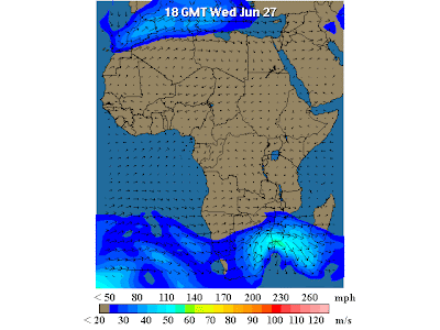
Once again there was really no big mystery when one could see things as they are.

Tuesday, June 26, 2007

Contrasts and extremes.

26th June 2007

By far the hottest event of the day was not Global Warming, nor the Greek heatwave, but the "liberation" of Paris Hilton from jail.

Liberation?

Well at least that's what CNN was calling it, and though some of its reporters freely admitted that it was not the most meaningful story in the world, it was certainly the most newsworthy.

If one felt one just had to become a little more serious the Greek heatwave offered a likely destination. Once again rumours of Global Warming were swift to surface and in the worst day of the heatwave so far temperatures in the Greek capital Athens topped 45 degrees centrigrade.

Now that's hot in anyone's language, and inevitably had people drawing easy conclusions that this just had to be Global Warming?

Well I always hate to ruin a good party once it's got goin' but if you take a look at the picture below it shows a considerably less mystical explanation to what is now officially a "killer heatwave". The image clearly shows a North Easterly directed wind flow off the deserts of North Africa towards South Eastern areas of the Mediterranean. Interestingly enough areas of northern Greece were not nearly as hot and this is because they were subject to winds that descended down from the North Atlantic before turning towards the Balkans to offer at least some measure of relief.


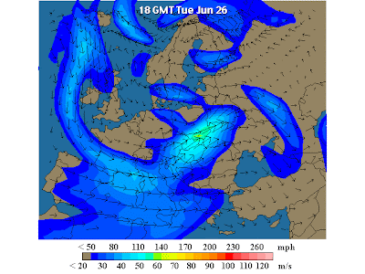
Britain meanwhile woke up to headlines of a highly disruptive storm that claimed at least 3 lives and left workers in at least one major city - Sheffield - needing to be rescued by helicopter.

Now if this wasn't Global Warming, then it just had to be that catch all phrase Climate Change? After all, the equivalent of at least one months rain had been dumped on areas of the British Isles in little more than 24 hours. In addition tornadoes wreaked havoc in numerous areas and this was not the sort of weather associated with a British Summer.

In actual fact these circumstances had a much more mundane origin. Warm winds from the tropics drifting up towards Britain became enwrapped in a swirling wind pattern centred directly above the British Isles. This allowed the rains to fall for longer than usual and the action of colder winds from the North saw to it that this was an especially explosive event - but one that is so easily explainable, if you look at the picture below, which can be enlarged by clicking on it.

Monday, June 25, 2007

Europe - Continent of stark contrasts.

25th June 2007

In Europe there were stark contasts between Northern areas encompassing the British Isles and the Southern-Eastern nations such as Greece and Turkey. In the latter named, the influence of the recent heat wave was undiminished, and temperatures of 43 degrees centigrade or higher, were a fair reflection of blazing winds that poured off the deserts of North Africa.

Meanwhile in Britain, and other areas of Northern Europe cool and wet conditions were the result of a complex weather system that swirled around the region with swiftly alternating temperatures, and a very unsummery outlook that was definitely no ones definition of Global Warming. I mean 14 degrees centigrade? What sort of temperature is that for a good summers day in England?

Apparently its entirely normal as the experts tell us!!!


Certainly there was no need to invoke either Global Warming, or Climate Change, to see the origins of this situation for what they really were - simply winds that happened to bring either devastatingly hot conditions, or the unpredictable variations far to the North.

With regards to the Greek heatwave it was interesting to note that not all of the nation was equally affected. In fact some regions recorded much lower temperatures - at least 10 degrees centigrade lower than others, simply because they weren't immediately in the track of the hot winds coming up from North Africa.

In fact this is a perfect illustration of the way winds of one direction or another can cause sharp variations of temperature within comparatively short distances. And once again there is not a whiff of carbon dioxide in sight - apart that is from the little that's escaping from my Coca Cola (trademark) as I write this bulletin.

Sunday, June 24, 2007

All normal on the European Front

24 th June 2007

The British Isles were subject to very changeable conditions, courtesy of a swirling weather system, that contributed cool and wet conditions interspersed with warmer weather that was disappointing for this time of the year. Meanwhile the Eastern Mediterranean continued to swelter with temperatures in the 40’s. So what exactly was this: Climate Change or Global Warming? Maybe it was even the Greenhouse Effect (Click here for more)?

In the end it was ascribed to just plain old normality - conditions that in neither case deviated from the way it has been for decade upon decade, and certainly could not be attributed to any sinister effects of carbon dioxide. As ever the culprit was the wind as it spilled off the deserts of North Africa to introduce hot baking air into parts of Eastern Europe.

As the image below shows quite plainly its simple when you really know why. (Click on image to enlarge)