Saturday, June 16, 2007
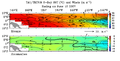
Eastern Pacific cooler than average
The reality is that in an extremely influential part of the Pacific Ocean - temperatures have shown below average readings since the turn of the year.
Now that’s something you don’t hear blazoned in feet high banner headlines in the press, and nor has it been mentioned much on TV.
I wonder why?
Seems to me that every shred of evidence - however tenuous in support of Global Warming gets acres of coverage - the complete opposite to anything that would tend to deny that most hallowed of New World religions - Climate Change Hysteria.
Anyway it turns out that whole areas of the Eastern Pacific have been cooler than normal since the beginning of the year. But hey this isn’t anything we haven’t seen before. It’s just a regular La Nina effect. Remember that from another by gone age?
For those who may be too young or just let it slip them by, El Nino is when areas of the Pacific Ocean gets warmer, and La Nina is when it gets colder. Turns out its an entirely natural effect. Nothing to do with the Human Race, and routinely decides the weather outlook for large swathes of the planet. And if you’re thinking that maybe this hoo-hah about so called global warming is really no more than our old friends La Nina and El Nino in action then you would be entirely right.
For more on the cooling in the Pacific Ocean please turn to the following link
http://www.bom.gov.au/climate/enso/#basics
Below shows the temperature cooling in graphic form with the top bar showing the mean readings , and the bottom bar the current cooling effect.
16 th June - unsettled Western Europe. Hot Eastern USA.
Wrong actually!! In fact experts say it was merely a more potent example of average early June conditions of the sort that habitually wipes out the first week at Wimbledon and turns the Glastonbury Festival into a quagmire.
So no climate change here then.
For more convincing global warming evidence there was a spell of sweltering conditions down the eastern coastline of the USA, with New York well into the 30's centigrade.
So global warming at last? Well not quite. As the attached map shows this hot spell was more due to warm winds coming up from the Pacific and the Gulf of Mexico. Once again a straight forward explanation that is evident to anyone.
Friday, June 15, 2007
15th June. Strong winds over Britain - Heat in Greece.
But surely this latter was the result of global warming as reported on Greek state run TV ERT. Well no actually!! Simply the result of winds coming off the deserts of North Africa. Hardly a mystery when you really bother to look.
Thursday, June 14, 2007
14th June 2007: Unseasonal rain for Northern Spain.
The south of England basking in the southerly wind flow remained surprisingly warm with London at 26 centigrade. On the other hand northern areas could barely reach 15 centigrade - a significant difference, and on this occasion barely two hundred miles was enough to separate summer climes from a decidedly wintry outlook - proving in a way that the weather we receive is almost entirely dependent on the wind directions and not so called atmosphere warming clouds of carbon dioxide.
Further south meanwhile winds came streaming across the Atlantic from the American continent bringing heavy rains to the North of Spain. Such downpours at this time of the year may be considered ununusual, but as the picture below illustrates this has nothing to do with carbon dioxide levels, and everything to do with the winds racing across the Atlantic. So not much of a mystery after all !!
Further afield, but not covered by these maps, the Russian capital Moscow sweltered in temperatures of over 35 centrigrade. Global Warming? No! Simply a long stream of wind that stretched southwards right on down to the Sahara Desert. Once again an easy explanation for anyone who really bothers to find the answers.
Wednesday, June 13, 2007
June 13th - Unsettled and rainy UK weather
Tuesday, June 12, 2007
A change of winds.
Two weeks in late May and early June typified the complexity of the debate revolving around Global Warming. Many areas of Europe saw widely contrasting conditions within a very short time. This meant swift changes between relatively cold and wet weather, to dry and hotter conditions or vice versa .
Not surprisingly the Global Warming brigade attributed this to the actions of humanity and increased levels of carbon dioxide. Yet as these pictures of the prevailing winds - the Jet Stream - clearly indicate, the cause is very evidently the change of wind direction and nothing more. On the 27th of May the picture of the Jet stream shows a northerly flow of winds over Britain that created one of the coldest ends to May within living memory.
Barely days later the situation was reversed with southerly winds that blew hot and dry conditions over the British Isles for a period of close on two weeks (see image below) Winds that moreover blew up almost unimpeded from South America to the North African coastline before heading up towards Britain.
These two instances quite graphically illustrate that temperatures are not dependent on levels of carbon dioxide but on straight forward factors of wind direction.
It couldn’t be simpler. In the northern hemisphere when the wind blows from the south you get warmer conditions, and when it blows from the north colder weather takes over. This is the way it has always been , and to any objective observer, so called changes in climate are quite easily explainable as a shift in global wind patterns, that this site is pleased to explore for the education of all.


