 26th June 2007
By far the hottest event of the day was not Global Warming, nor the Greek heatwave, but the "liberation" of Paris Hilton from jail.
Liberation?
Well at least that's what CNN was calling it, and though some of its reporters freely admitted that it was not the most meaningful story in the world, it was certainly the most newsworthy.
If one felt one just had to become a little more serious the Greek heatwave offered a likely destination. Once again rumours of Global Warming were swift to surface and in the worst day of the heatwave so far temperatures in the Greek capital Athens topped 45 degrees centrigrade.
Now that's hot in anyone's language, and inevitably had people drawing easy conclusions that this just had to be Global Warming?
Well I always hate to ruin a good party once it's got goin' but if you take a look at the picture below it shows a considerably less mystical explanation to what is now officially a "killer heatwave". The image clearly shows a North Easterly directed wind flow off the deserts of North Africa towards South Eastern areas of the Mediterranean. Interestingly enough areas of northern Greece were not nearly as hot and this is because they were subject to winds that descended down from the North Atlantic before turning towards the Balkans to offer at least some measure of relief.
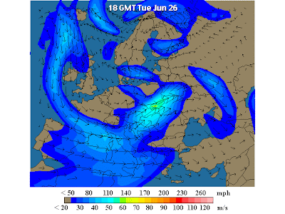 Britain meanwhile woke up to headlines of a highly disruptive storm that claimed at least 3 lives and left work
 ers in at least one major city - Sheffield - needing to be rescued by helicopter.
Now if this wasn't Global Warming, then it just had to be that catch all phrase Climate Change? After all, the equivalent of at least one months rain had been dumped on areas of the British Isles in little more than 24 hours. In addition tornadoes wreaked havoc in numerous areas and this was not the sort of weather associated with a British Summer.
In actual fact these circumstances had a much more mundane origin. Warm winds from the tropics drifting up towards Britain became enwrapped in a swirling wind pattern centred directly above the British Isles. This allowed the rains to fall for longer than usual and the action of colder winds from the North saw to it that this was an especially explosive event - but one that is so easily explainable, if you look at the picture below, which can be enlarged by clicking on it.
